

(Figure 58: The map after uploading GCP's and customizing options, ready to process!)

(Figure 57: GCP and MTP Manager, where you upload your GCP as a text file.)

(Figure 56: The Pix4D application after narrowing down what photos need to be processed.)

(Figure 55: Images from the mission flown shown in folder.)

(Figure 54: CORS website needed for gathering files needed for data processing.)

(Figure 53: The home page for Pix4D)

(Field Notes 2: The notes taken before, during, and after the flight.)

(Figure 48: Setting up the C-Astral for it's first flight.)


(Figure 50: C-Astral ready for take off.)


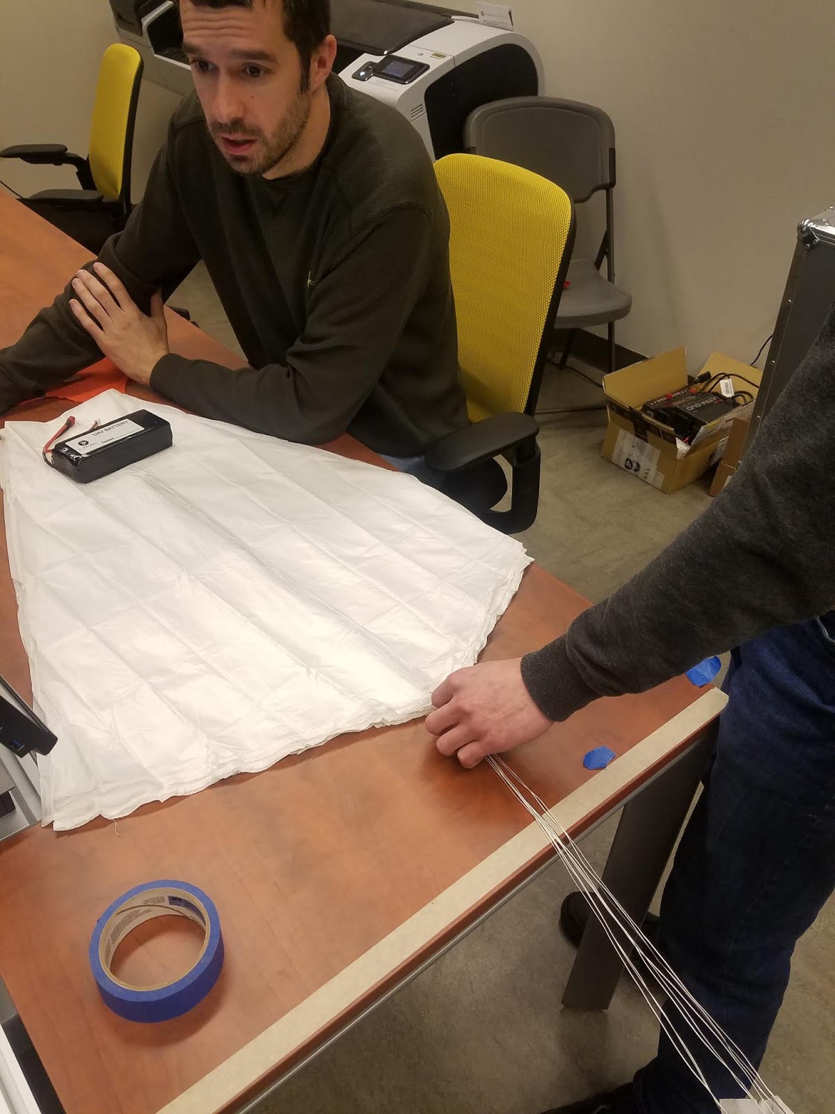
(Figure 47: Fresh parachute folding by Ian and Todd.)

(Figure 44: Completing checklists for the dry run on the C-Astral.)

(Figure 43: Another dry run on the C-Astral)

(Figure 42: The gimbal being checked and secured on the M600.)

(Figure 41: The M600, being checked for a final time to prepare for future flight.)

(Figure 40: The A8000 Payload)

(Figure 39: The A8000 Payload)

(Figure 38: The time it took for Run Through 2)

(Figure 37: The time it took for Run Through 1)
| Pilot | Co-pilot | Equipment Member 1 | Equipment Member 2 | Time From Start to Launch | Needs Improvement | |
| Run Through 1 | Todd | Kyle | Evan | Ryan | 56 Minutes 48 Seconds | Storage of Catapult, Camera Setup, Pitot Checks |
| Run Through 2 | Evan | Thomas | Ryan | Todd | 38 Minutes 2 Seconds | Checklist Order, GCS Checklist, Parachute Packing Installation |
(Figure 36: Table for Run Through 1 and Run Through 2)

(Figure 24: The case for the C-Astral)

(Figure 25: The Wings of the C-Astral in their case)

(Figure 26: The launching mechanism it it's case)

(Figure 27: The team pulling out the catapult into an open area.)

(Figure 28: Professor Hupy and Ryan setting up the elastic bans making sure not to get any of the bans twisted. If twisted, the catapult could fail and damage the C-Astral.)

(Figure 29: The safety pin and launching mechanism for the catapult. It is very important to double check the safety is armed and working properly before trying to set up the C-Astral.)

(Figure 30: The C-Astral with wings attached)

(Figure 31: Working on making sure the parachute is packed, and attached to the C-Astral.)

(Figure 32: The C-Astral mounted on the catapult.)

(Figure 33: The tablet we will be using to plan out flights with the C-Astral. On it you can see the interface of the mission planner we will be using.)

(Figure 34: Kyle explains some of the key elements on preflight work with the tablet.)

(Figure 35: The underbelly of the C-Astral where the payload is located.)

(Figure 23: Measure mobile app flight mode.)

(Figure 22: Measure mobile app flight planning)

(Figure 21: Measure mobile airspace map used for planning flights.)

(Figure 20: Measure mobile rules and advisories section)

(Figure 19: Drone Log Book mobile app home page option)

(Figure 18: Measure mobile app home page.)
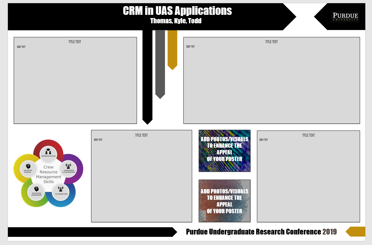
Figure 17: The layout of the CRM in UAS Applications Poster.
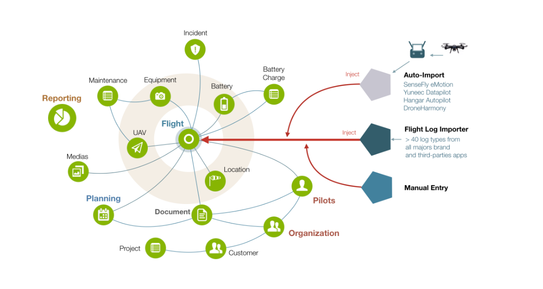
Figure 16: Above is a Nexus that Drone Log Book as created about their application.
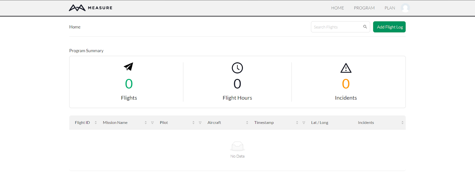
Figure 14: The home page of Measure.

Figure 15: The home page of Drone Log Book.

Above: (Figure 13) - Notes for a Crew Resource Management Poster made my Kyle and myself.

Above: (Figure 12) - Notes from our dry run class activity.

Above: (Figure 11) - Integration continued

Above: (Figure 10) - Our head payload integration guy, integrating the X5 on the M600.

Above (Figure 9): M600 in its case.

Above: Figure 8 - Picture of me outside in my Ford in subfreezing temperatures.

Above: Figure 7 - The first completed parachute packing done by Todd and Ian.

Above: Figure 6 - Todd and Ian work on packing their first parachute.
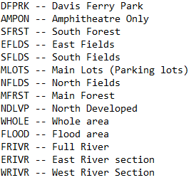
Above: Figure 5 - 5 letter identifiers created to help organize shape map.

Above: Figure 4 - Shape map of flight areas created by Kyle and Evan using Arcmap.

Above: Figure 3 - The meta data from we decided would best fit our flights for this project.
Below: The Coyote Crossing Golf Club is another location that we are thinking about for our capstone class. For this location to work Dylan McQueen would need be a liaison, already doing some work at this golf club. This location also has a different variety of landscape and offers a variety of projects that we could do for the class.


Above: The amphitheater close up from the Tippecanoe County Amphitheater Park.
Below: A possible location for our capstone class project next semester. The Tippecanoe County Amphitheater Park is a great location because it includes a variety of landscapes including, forests, fields, rivers, roads, and the amphitheater itself that allows us to be able to conduct different data collection and collect more data than other locations.

Below: These four images were screenshots taken on my computer while working on learning about geospatial video. The program used for this lab was Video Geotagger. Below you can see the different phases of going through this software that are covering in more detail on my post about Geospatial Video.


Project Timeline
Checkpoint
|
Timeline
|
Capstone Project Proposal
|
September 2018
|
Project Development
|
October 2019
|
Annotated Bibliography and Timeline
|
November 2018
|
Discussion with pilots on project team
|
December 2018
|
Strategy meeting with group
|
January 2018
|
Flight 1 unmanned aircraft
|
February 2018
|
Flight 2 manned aircraft
|
March 2018
|
Write up on project
|
March 2018
|
Below: Professor Hupy covering mission planning with a new pilot.


Above: Me calibrating the drone with pilot Krysta Roll's help.

Above: A ground control point set out for our mission at Hupy's house. Careful notes were taken to make sure we kept track of the order the ground control points were placed.

Above: The mission planning done at Professor Hupy's house (November 8th, 2018)
Below: Some GIS work done by Dr. Elizabeth LaRue that relates to projects were are doing in class!


Above: Professor Sorin shows us the Orbis project and what improvements GIS could make.
Below: Dr. Picard shows some mistakes that were made in a GI project and what lessons we should learn from those mistakes.


Above: The DJI Drone used to conduct the mission flown on October 29th at McCormick Woods.


Nexus of Relations
Current and Future UAS Industry Trends
Trends
|
Explanation
|
Beyond Visual Line of Sight (BVLOS)
|
Fixed wing aircraft flying along rail lines. ~5-hour missions
|
Rail inspection
|
Mapping yards and switches
|
Pipeline Inspection
| |
Advanced Ground Control GPS
Technology
|
New technology that allows for faster collection of Ground Control Tie-Ins. Aeropoints as an example
|
Autonomous Delivery
|
(Concept): Amazon delivering packages via UAS
|
Construction
|
Site scans, progress reports, overview images
|
High Resolution Remote Sensing
| |
Airspace Integration
|
Flying in/near airports & Runway inspection
|
Swarm Technology
|
Multiple autonomous platforms working together to complete one goal.
|
Natural Resource Management
|
Resource inventory, change analysis, productivity and condition analysis.
|
Windmill Inspection
|
Reducing operation & maintenance costs
|
Manned-Unmanned Team (MUMT)
|
Drones and manned aircraft utilizing same airspace or target area to collective gather data or accomplish similar task.
|
Vegetation Mapping
|
Monitoring vegetation growth using hyperspectral NIR
|
Water column mapping
|
Using differences in reflected/refracted light received by a sensor to map vertical columns of water based on depth.
|
Hazard Risk Assessment (weather, geological, environmental, etc)
|
Fault line mapping, water drainage mapping, flood plain mapping, slope stability analysis, forest fire risk analysis
|
Real Estate Marketing
|
Arial images of various angles of the house/property, neighborhood images
|
All weather operations
|
Weatherized airframe
|
Site Surveying
|
Matching point clouds with CAD elevation maps
|
Energy
|
Used to assess pipelines and energy networks
|
Light Shows /leisure /recreation
|
Companies like Intel use drones for entertainment purposes
|
Accident Reconstruction
|
Post-crash scene scans, gather information to show police, juries, investigators, etc.
|
Search and Rescue
|
Emergency services searching vast areas for missing persons
|
RC Racing
|
Innovation through commercial application utilizing the entertainment markets.
|
Firefighting
|
Assistance in finding safe routes of use. Thermal imaging and analysis.
|
Police
|
Documenting crime scenes, surveying disaster sites, accident & traffic management
|
Emergency (medical)
|
Delivery of medical supplies (Zipline company)
|
Cinematography
|
Take a video of it
|
Agriculture
|
Can collect crop count and assess crop quality
|
Surveillance
|
Can be used to monitor any high security area
|
Deep learning flight controls and data processing
|
Unsupervised data management and classification.
|
Full Motion Video
|
Video Taken in MISB format. Video has bounding Geospatial coordinates
|
Geospatial Video
|
Video connected to UAS log file so it has coordinates
|
Policy and Regulation
|
More structure to UAS Commercial Remote Pilot License Categories. Also relates to certification of different classes of aircraft.
|
Increasing Markets and Applications of Tethered UAS platforms
|
Tethered power supply UAS platforms have the potential to serve for long term surveillance and other services where
|
More efficient Solar Panel Arrays
|
Increased flight times can come from axillary solar panels that provide trickle charge to the electric power source to the UAS
|
UAS Critical Skills and Knowledge
Skillset/Knowledge
|
UAS Course Applied to:
|
Project Management
|
AT 203
|
Geospatial Knowledge
|
AT 319
AT 309
|
Cartographic Knowledge
|
NA
|
Post-Processing of UAS data
|
AT 319 (Small component)
|
Integration with GIS and RS software
|
NA
|
Quick-thinking/adaptability
|
Throughout curriculum
|
Regulation Knowledge
|
AT 144
AT 286
|
Repair and Maintenance
|
AT 219
|
Flight Proficiency
|
AT 219
AT 309
|
Sensor Integration/Familiarity
|
AT 309
|
Remote Sensing
|
AT 319
|
Quality control of data
|
NA
|
Data management/Computer Science
|
NA
|
Integration with manned aircraft
|
AT 286
|
Potential/Future Applications
|
AT 409
|
Technical Writing
|
AT 409, ENG 420
|
Programming
|
NA
|
Management
|
Entrepreneurship Certificate
|
Marketing
| |
Graphic Communication
| |
Ethics
|
AT 309 AT 319
|
Soldering
|
AT 219 AT 309 AT 319
|
Systems Engineering
|
Lightly throughout curriculum
|
Electronics design
| |
UAS Technician Key Duties
Mission Planning
|
Description
|
Airworthiness Inspection
|
Ensuring aircraft is in a safe condition to fly and in compliance to manufactures guidelines.
|
Airframe integrity inspection
|
Checking critical parts of the aircraft for structural integrity. Search for deficiencies that may limit flight characteristics
|
Find the highest object in flight path
|
For collision avoidance, ensures that your flight altitude will not hit any obstacles
|
Gather weather data
|
Weather must be within the aircraft’s and your personal limitations
|
Airspace analysis
|
Must get permission in certain airspace
|
Data capture and quality considerations
|
Must know how to read sensors and calibrate equipment correctly to get accurate readings.
|
Sensor selection
|
Choosing the correct sensor for the mission at hand
|
Geospatial Duties
| |
Plan out missions using various forms of geospatial data
| |
Understanding capabilities and limits of Sensors and UAS platforms
| |
Being able to apply the right sensor and platform to the job
| |
Being able to properly gather Ground Control Points with survey grade GPS
| |
UAS Maintenance
| |
Ensure proper record keeping
|
Proper record keeping of replaced and repaired parts. Proper record keeping of flight time and incidents.
|
Standardization of maintenance techniques (like AC 43.13)
| |
Maintain Scheduled Maintenance Plan/Logs
| |
Software Troubleshooting
| |
Regular inspection of flight critical parts
| |
Knowledge of UAS maintenance software and applications
| |
Maintaining Field Kit
| |
Flight Operations
| |
Maintain Safe Conduct Throughout Flight
| |
Crew Management
| |
Preflight Operations
| |
Post-flight checklists
| |
Proper Debriefing
| |
What belongs in a UAS field kit
| |
Repair techniques and procedures
| |
Data Capture Considerations
| |
Communication
| |
Customer interaction
| |
Marketing /Networking
| |
Non-crew teamwork
| |
Crew Resource Management
| |


No comments:
Post a Comment